GeoEDF Workflow Framework, application highlights
About
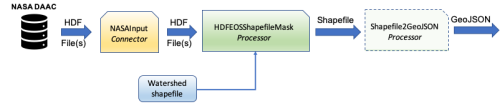
GeoEDF is an extensible data framework designed to simplify data wrangling in geospatial research workflows. GeoEDF enables researchers to define scientific workflows as a logical sequence of data acquisition and processing steps.
Reusable building blocks termed data connectors and data processors implement data acquisition from various repositories using various data access protocols, and a range of domain-agnostic domain-specific geospatial processing operations respectively.
The GeoEDF framework defines the syntax and semantics of connectors and processors, while the engine implements the validation, transformation, job planning, and execution of declarative GeoEDF workflows encoded in YAML syntax.
Objectives
- Learn how to write a workflow using published GeoEDF connectors and processors
| Type | Module |
|---|---|
| Level | Developer |
| Length | 2 hours |
| Earnable |
 Completion of GeoEDF Workflow Framework, application highlights
|
| Topics |
processors workflow |
Instructor

Jungha Woo

Christopher S Thompson
Discussions
Please login to view discussions.